
Event tech & Operations
The Complete Guide to Event Maps & Wayfinding for Conferences
How to help attendees find sessions, booths, and coffee at big events
Subscribe for insights on AI- powered event apps, engagement strategies, and to learn more about how event teams are driving measurable results.


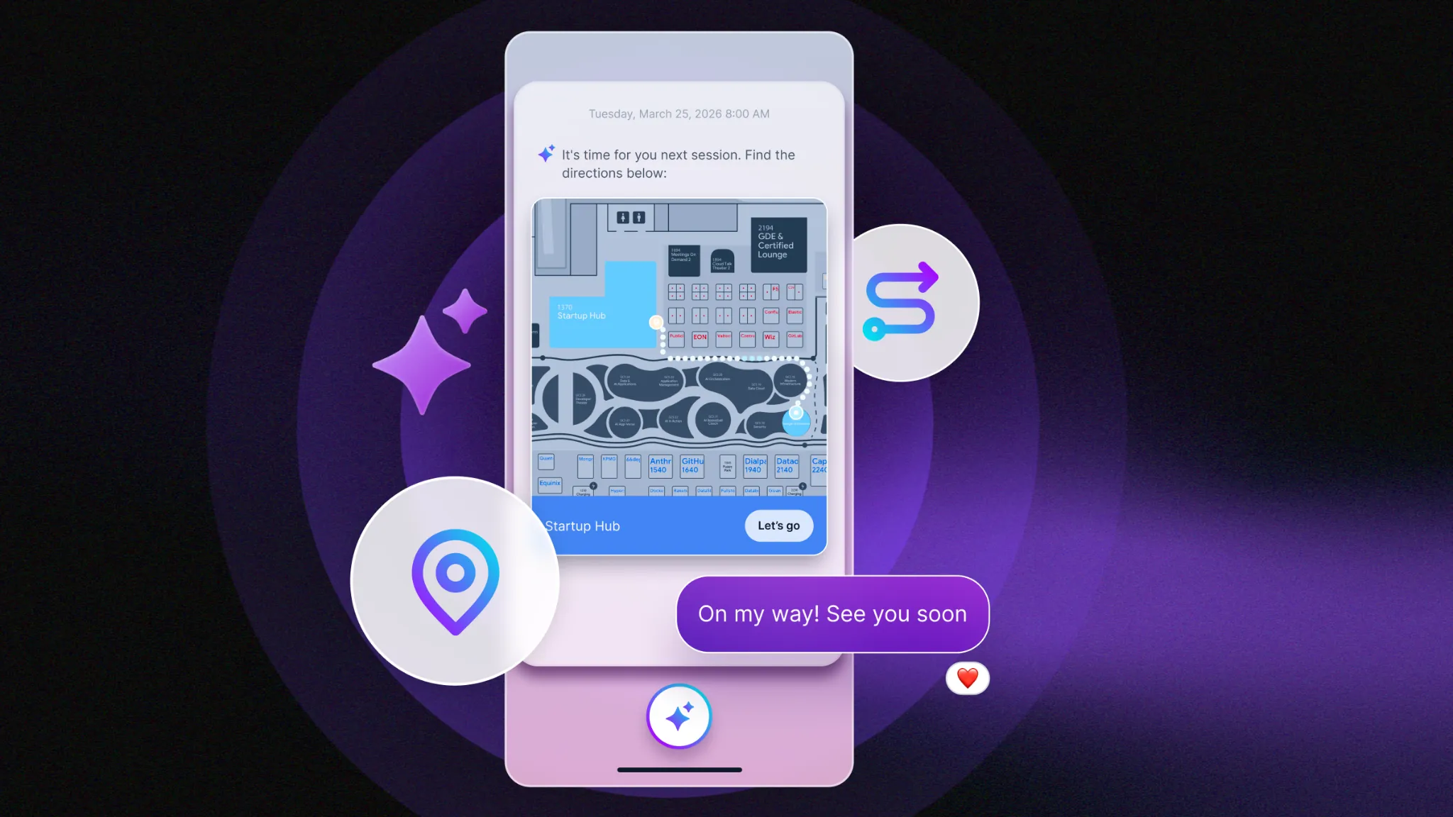
The question that fills the first ten minutes of every big conference is not about content. It is "Where is the keynote?" Then "Where do I register?" Then "Is there coffee on this floor?"
If you have run a show, you know the pattern. Attendees arrive, put their phones in front of their faces, and wander. Your signage is solid. Your staff are friendly. And still the person who flew in from another time zone is standing in front of a wall of room names, trying to work out which hallway leads to Hall C.
This guide covers how event wayfinding works, how digital event maps differ from the PDF in your attendee email, and what organizers can do to help people move around a large venue. It is written for event marketers and operations teams planning real events with real floor plans, so it sticks to what you can actually act on.
Event wayfinding is the set of tools and cues that help attendees figure out where they are, where they need to go, and how to get there. That includes physical signage, printed maps, staff directions, and digital tools like interactive event maps and indoor navigation on a phone.
Good wayfinding answers three questions in order. Where am I? Where is the thing I want? What is the easiest way to get there? Most events cover the second question reasonably well, since the room list is on the schedule. The first and third are where people get stuck.
Conference wayfinding has an extra layer that retail or airport wayfinding does not. Attendees are not just looking for a place. They are looking for a place at a specific time. A session room that is easy to find at 9:00 a.m. can be a sprint at 9:55 when the previous session lets out two buildings away.
People use the two terms interchangeably, but they solve different problems.
An event map shows the layout. It tells attendees what exists: halls, breakout rooms, booths, restrooms, registration, the networking lounge. A good map is accurate, readable on a phone, and tied to the agenda so a session location is one tap away.
Wayfinding goes one step further and helps people move through that layout. It can be as simple as a clearly labeled route on a map, or as advanced as turn-by-turn directions with a live position marker, often called a blue dot.
The practical takeaway: you do not need to start with the most advanced option. A clean, well-linked map solves a lot of problems. Blue-dot navigation earns its place when the venue is big, spread across multiple levels, or confusing enough that a static map is not enough.
Navigation problems at conferences are rarely about one missing sign. They usually come from a few repeating causes.
If attendees have to read a room name in the schedule, open a separate PDF, and then hunt for that name on a floor plan, they are doing three steps your app could do in one. Every extra step costs minutes at the exact moment people are trying to get to a seat.
The venue calls it Ballroom B. The agenda says Main Stage. The signage says Hall 2. Nobody did anything wrong, but the attendee is now translating between three naming systems on the way to a keynote.
A single-floor hotel ballroom is one problem. A convention center with four levels, escalators in unexpected places, and a skybridge to the next hotel is a different one. Attendees lose time on the last 50 feet of a route, when they are close but cannot see the entrance.
Rooms change. Sessions move. A speaker swaps a slot and a breakout lands on a different floor. If the map and schedule do not update together, the information attendees trust most becomes the information most likely to be wrong. Our guide to multi-track event schedule management covers how teams keep the schedule current when plans shift.
Digital event maps come in a few forms. Which one fits depends on your venue, your audience, and how much of the event runs on a show floor.
A PDF map inside your event app is the simplest option and a real improvement over a PDF buried in an email. Attendees can open it in the app, zoom in, and jump to it from a session or agenda item. For a single-venue conference with a straightforward layout, this can be all you need.
Interactive floor plans let attendees search, tap, and explore. They are especially useful on an expo floor, where the question is not "where is Room 204" but "where is booth 1138 and who else is near it." Exhibitors become searchable, and attendees can build a path through the hall before they start walking.
This is the option that shows an attendee where they are standing and draws a route to where they want to go. It relies on indoor positioning, which depends on the venue and on the technology behind it. It is the strongest fit for large, multi-level venues, and it takes more planning than a PDF. Blue-dot positioning depends on compatible integrations and on how the venue is configured, so check the venue early in planning rather than a week out.
You do not need a complete technology overhaul to improve navigation. These steps work whether you use a PDF map or full indoor navigation.
Before the event, take your agenda and walk the three most common routes with your phone at 20% battery and no staff badge. Start at the main entrance, go to registration, then to the first keynote, then to the closest coffee. Note every spot where you hesitate. Those are your signage and map problem areas, and you will find them faster than any survey can.
Decide what each room is called, and use that name on the agenda, the map, the signage, and the app. If the venue's official name is confusing, give rooms names attendees will recognize and tell the venue's team which ones you chose.
The most useful thing a digital map can do is remove the hunt. When a session listing links straight to its room on the map, attendees skip the guesswork. In Amego, maps are accessible from session details and personalized agendas, so the location sits beside the schedule instead of in a separate document.
Navigation problems cluster at transitions: the ten minutes between sessions, the rush after a keynote, the lunch break. Identify those moments on your run of show and put extra signage, staff, and push reminders there. A nudge that tells attendees where their next session is and how long the walk takes does more at 10:50 than a better map does at 8:00.
Maps answer questions people already know to ask. Proactive guidance helps with the ones they do not. Sidekick, Amego's AI companion, can send recommendations and session reminders based on where attendees are and what is nearby when it is paired with location-aware wayfinding. Learn more on the Sidekick AI event app page.
Conference center wifi is a famous source of heartbreak. Ask whether your map loads quickly with a weak connection, and test it in the spots with the worst reception, like basement meeting rooms and crowded halls.
Even the best map does nothing if people do not open the app. Promote it in your pre-event emails, your registration desk, and your opening remarks. Cloudflare reached 98% app adoption across its global events with Amego, and you can see how in the Cloudflare success story. For benchmarks and ideas, see our event app adoption rate benchmarks.
Wayfinding is a sponsor and exhibitor issue, not just an attendee comfort issue. A booth that attendees cannot find is a booth with fewer conversations, fewer scans, and a weaker case for renewal.
An interactive floor plan with searchable exhibitors gives sponsors a way to be found, not just seen. When attendees can search a company name and see the booth location, foot traffic stops depending on who happens to walk past. Pair that with lead scanning and exhibitors can connect the dots between being found, being visited, and following up.
If you run trade shows or large conventions, our page on conventions, trade shows, and associations shows how these tools fit together, and our sponsors and exhibitors page covers the exhibitor side.
If you are asking what the best event mapping solutions are, the honest answer is that it depends on your venue. A floor plan tool built for expo halls is not the same as an indoor positioning system built for a multi-level campus. Here is how the main options break down.
Amego supports maps through its event maps and wayfinding feature, which starts with native PDF maps in the app and extends to interactive floor plans and indoor navigation through partner integrations. The partner list includes:
You can browse the full list on Amego's integrations page. Which partner makes sense depends on the venue. Expo-heavy shows usually start with a floor plan tool. Large campuses and multi-level venues are where indoor positioning pays off. If you are still choosing an app for a big event, our guides to choosing an event app for a large conference and the best event apps for trade shows are good next reads.
Before you commit to a mapping approach, put these questions to every vendor and to your venue.
Ask to see a real customer event, not a demo venue. A map that looks clean in a sales deck can behave very differently in a venue with six levels and a skybridge. If you are comparing app features more broadly, our event app features guide is a helpful checklist.
Event wayfinding is the combination of signage, maps, staff guidance, and digital tools that help attendees find their way around an event venue. At conferences it covers finding session rooms, registration, exhibitors, and amenities.
Organizers can improve navigation by using one room naming system everywhere, linking sessions to locations on the map, adding extra support at peak transition times, and testing routes before the event. Venues with multiple levels or buildings often benefit from indoor navigation with a live position marker.
The best option depends on the venue. Native PDF maps work for simple layouts. Interactive floor plans, such as ExpoFP, suit trade shows. Indoor wayfinding from partners like Crowd Connected and Pointr fits large, multi-level venues. Amego connects these options to its mobile event app.
An event map shows the layout of a venue. Wayfinding helps people move through it, often with routes, search, and live positioning.
That depends on the tool. Ask every vendor how its map loads on a weak connection and test it in the worst-reception areas of your venue before the event.
Yes. Searchable floor plans make it easier for attendees to find specific booths, which supports foot traffic and gives sponsors a better shot at meaningful conversations.
Nobody goes to a conference to admire the floor plan. They go for the keynote, the conversation in the hallway, the demo that changes how they think about a problem. Wayfinding matters because every minute spent lost is a minute taken from the reason they came.
The goal is simple: make the venue feel smaller than it is. Start with a map that works, link it to the agenda, and add guidance where your venue demands it. If you want to see how Amego handles maps, sessions, and attendee guidance in a single branded app, you can schedule a demo and talk it through with people who have run these events.
New guides, benchmarks, and what we’re seeing on show floors. Written by event people, for ones running showtime.